Exhaustives et ultra-précises sur les frontières maritimes en Arctique : voici les cartes du Centre de recherches sur les frontières internationales de l’université de Durham, au Royaume-Uni.
Les cartes et leurs commentaires sont en anglais.
Les informations sont mises à jour régulièrement (ici juillet 2019), en reprenant les travaux de la Commission des Limites du Plateau Continental de l’ONU.
C’est une source de référence sur les revendications actuelles des différents Etats de l’Arctique quant aux limites de leurs ZEE.
Extraits :

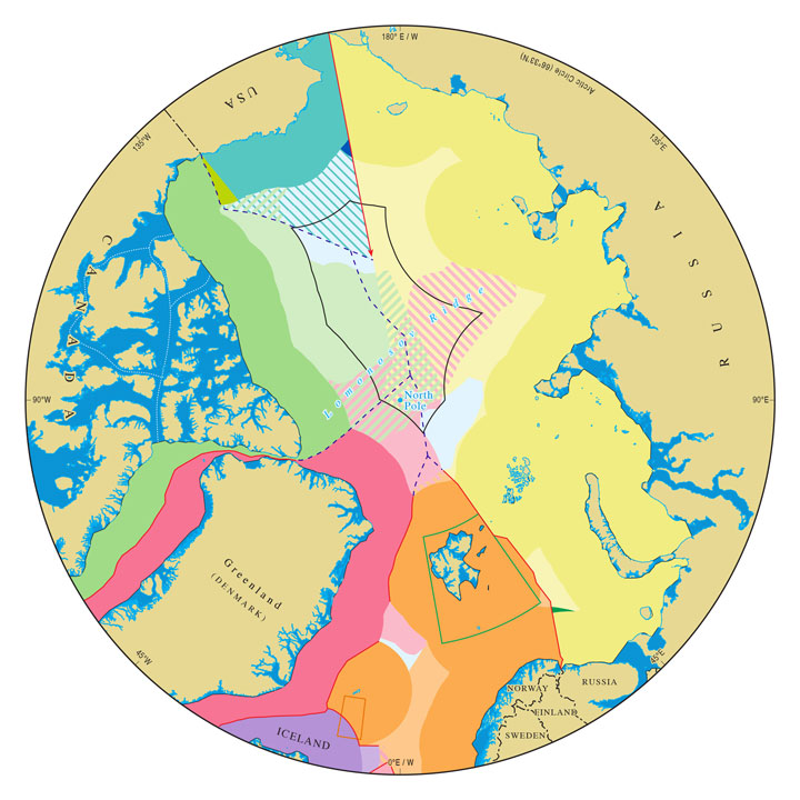
This is the original IBRU Arctic map, first released in 2008 and revised several times since. It presents a comprehensive view of hypothetical continental shelf claims (for the USA), submitted claims (for Canada, Denmark and Russia), and approved claims (for Iceland and Norway). Additionally, the map indicates internal waters, territorial seas, and exclusive economic zones for each of the Arctic coastal states, special areas within exclusive economic zones, and the one area of dispute in the Arctic Ocean (in the Beaufort Sea, between the USA and Canada). Accompanying briefing notes detail the history and legal status of the various zones portrayed on the map.

This is a simplified version of the ‘maritime jurisdiction and boundaries’ map that focuses on claims to the outer continental shelf: the area more than 200 nautical miles from shore and beyond the limits of exclusive economic zones. Additionally, this map indicates the extent of sea ice, showing the median September minimum for the period 1981-2010 and, for comparison, data from the most recent September (September 2018). This map is supplemented with four insets that highlight claims in the Central Arctic Ocean. Separate insets highlight the claims made by Canada, the Kingdom of Denmark and Russia, respectively, while a fourth inset highlights the 54,850 square nautical mile area around the North Pole where the three claims overlap.

Russia’s initial filing with the Commission on the Limits of the Continental Shelf, made in 2001, was the first submission received by the CLCS and was returned to Russia for lack of supporting evidence. In 2015, Russia submitted a revised filing. This map indicates the difference in area between the two filings.
